


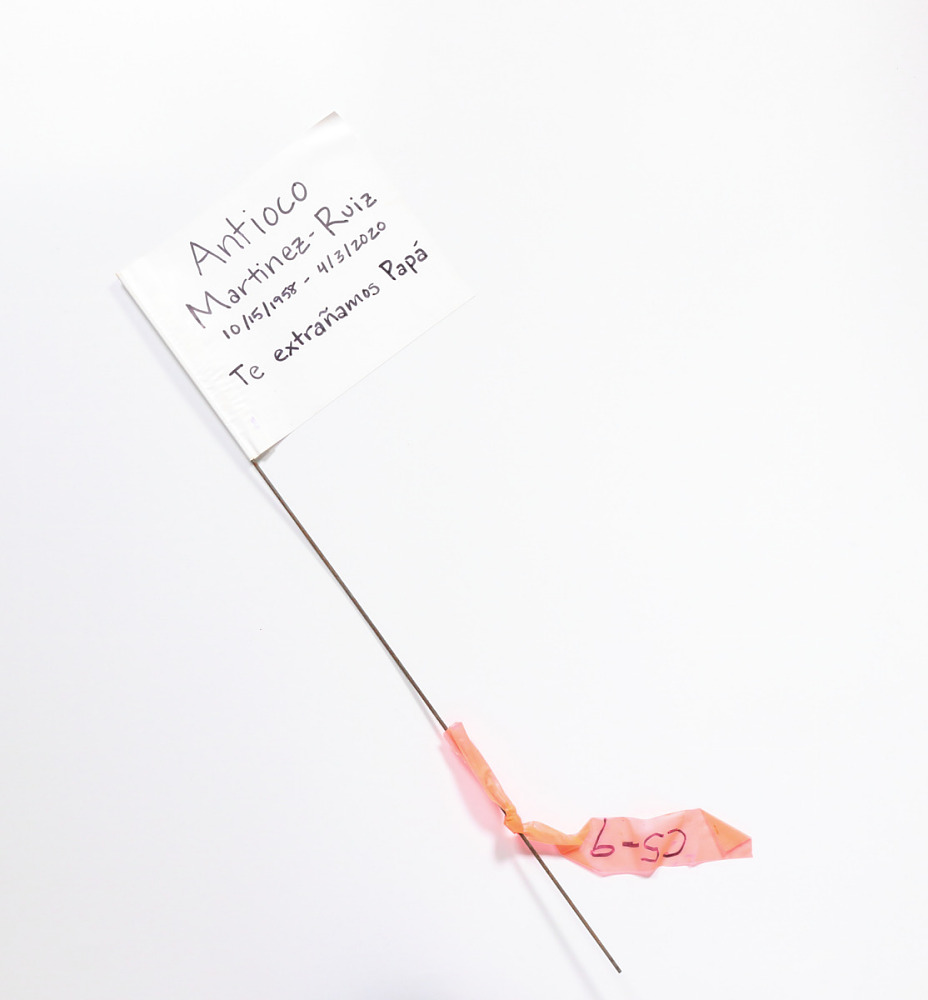
As COVID-19 deaths spiked in 2020, Suzanne Firstenberg’s public art installation "In America: How could this happen…"
History Explorer Results (37)
Related Books (2)
Grade Range:
5-12
Resource Type(s):
Primary Sources, Lessons & Activities, Worksheets
Date Posted:
1/22/2011
In this set of classroom activities developed for the exhibition America on the Move, students will use visual, analytical, and interpretive skills to examine primary sources including historical maps to answer questions about farming, transportation, immigration, and racism in
Grade Range:
5-12
Resource Type(s):
Primary Sources, Lessons & Activities, Worksheets
Date Posted:
1/22/2011
In these classroom activities developed for the exhibition America on the Move, students will use visual, analytical, and interpretive skills to examine primary sources including historical maps and answer questions about them to learn more about railroads, transportation, raci
Grade Range:
5-12
Resource Type(s):
Primary Sources, Lessons & Activities, Worksheets
Date Posted:
1/22/2011
In these classroom activities, developed for the exhibition America on the Move, students will use visual, analytical, and interpretive skills to examine primary sources including a historical map and photography by Dorothea Lange and answer questions about them to learn more a
Grade Range:
5-12
Resource Type(s):
Primary Sources, Lessons & Activities, Worksheets
Date Posted:
1/22/2011
In these classroom activities, developed for the exhibition America on the Move, students will use visual, analytical, and interpretive skills to examine primary sources including a historical map and answer questions about them to learn more about the expansion of transportati
Grade Range:
5-12
Resource Type(s):
Primary Sources, Lessons & Activities, Worksheets
Date Posted:
1/22/2011
In these classroom activities, developed for the exhibition America on the Move, students will use visual, analytical, and interpretive skills to examine primary sources including a historical map and answer questions about them to learn more about global consumption, productio

Grade Range:
K-12
Resource Type(s):
Artifacts, Primary Sources
Date Posted:
12/15/2010
During the colonial period, cattle horns were used by woodsmen and by soldiers for storing gunpowder in a safe, dry place. The horns also became decorative objects as they were personalized by the owner. Makers carved names, initials, dates, flags, battles, and even full maps on the exterior of t

Grade Range:
K-12
Resource Type(s):
Artifacts, Primary Sources
Date Posted:
9/3/2010
This Dutch map, made about 1655, shows eastern North America from what is now Canada to Virginia. Illustrations within the map include local wildlife as well as Indian villages on land, and Indians in boats at sea. The lower right corner of the map contains an inset of Nieuw Amsterdam, the third

Grade Range:
5-12
Resource Type(s):
Reviewed Websites
Date Posted:
9/1/2010
The Pentagon Memorial Fund’s Web site offers an interactive map of the memorial, a video and other information about events on 9/11 both at and beyond the Pentagon, a space to read and share personal stories, and links to related organizations.

Grade Range:
9-12
Resource Type(s):
Reference Materials, Primary Sources
Date Posted:
6/3/2010
Tell the story of early American science with an online exhibition and digital reproduction of the oldest surviving Anglo-American star map. This hand-drawn star map, created in 1780, reflects a story of scientific curiosity and the practical applications of astronomy in colonial America. Simeon

Grade Range:
K-12
Resource Type(s):
Artifacts, Primary Sources
Date Posted:
5/6/2010
This oval lady's compact is made in the shape of a telephone dial. On the dial appears "I LIKE IKE," with a map of the United States in the center. The point is that anywhere you might dial over the country, everybody likes Ike!


