


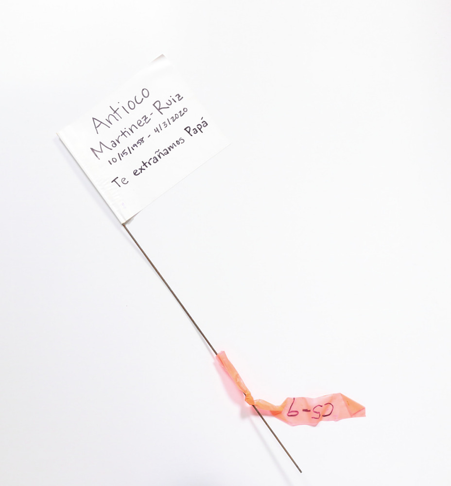
As COVID-19 deaths spiked in 2020, Suzanne Firstenberg’s public art installation "In America: How could this happen…"
History Explorer Results (37)
Related Books (2)

Grade Range:
4-12
Resource Type(s):
Reviewed Websites
Date Posted:
10/3/2009
This website allows students to take a tour of Sturbridge village, a living history museum that replicates rural live in the nineteenth century. Students who use this site will gain an understanding of early rural American life by navigating an illustrated map, searching an online artif

Grade Range:
6-8
Resource Type(s):
Primary Sources, Lessons & Activities, Worksheets
Date Posted:
9/12/2009
In this activity, one of three on the Bracero Archive website, students will examine an oral history related to the Bracero worker program and present their research on a map.
The Smithsonian's National Museum of American History is part of a consortium of m

Grade Range:
2-6
Resource Type(s):
Reviewed Websites, Interactives & Media
Date Posted:
9/1/2009
This interactive Web site from Plimoth Plantation, a Smithsonian Affiliate, focuses on clarifying fact and fiction surrounding the "First Thanksgiving." Students use audio from Plimoth Plantation historians, images of artifacts, and a glossary to answer questions and explore the lives of the Wama

Grade Range:
K-12
Resource Type(s):
Reviewed Websites
Date Posted:
8/6/2009
This website is a comprehensive set of web based resources and activities suitable for students at every grade level. Produced through a collaborative partnership including the National Park Service, the University of Houston, The Gilder Lehrman Institute of American History, and the Chicago

Grade Range:
3-12
Resource Type(s):
Reviewed Websites
Date Posted:
8/6/2009
This website, produced by students from the University of Michigan, focuses on the communications of American and English spies during the Revolutionary War. The site includes a gallery of eleven different spy letters, stories about spies during the Revolution, a timeline showing impor

Grade Range:
3-12
Resource Type(s):
Reference Materials
Date Posted:
6/17/2009
This online exhibition focuses on the natural history specimens that were collected by Lewis and Clark on their historic expedition. The site contains images of museum specimens, scientific drawings, and field photos of the plant and animal species observed and described by Lewis and Clark, along

Grade Range:
5-12
Resource Type(s):
Reviewed Websites
Date Posted:
6/17/2009
This website, produced by the Missouri Historical Society, was produced to coincide with a traveling exhibition celebrating the bicentennial of the Lewis and Clark exhibition. Students can explore the entire journey of Lewis and Clark and the Corps of Discovery through the use of an interac

Grade Range:
4-12
Resource Type(s):
Reference Materials
Date Posted:
6/4/2009
Students will learn about the virtually simultaneous introduction of English, French, and Spanish culture to this vast area and tells the stories of Native and European societies through 1700. Downloadable PDFs are included to relate the themes addressed in the exhibition to standards of learning

Grade Range:
4-12
Resource Type(s):
Reference Materials
Date Posted:
10/21/2008
Students can learn about the Lynches and the realities of life for many Americans during the Industrial Revolution by examining a map and description of their apartment, a page from an 1885 account book, and objects from the period. In the 1870s and 1880s, Catherine Tracy Lynch, an Irish imm

Grade Range:
K-12
Resource Type(s):
Artifacts, Primary Sources
Date Posted:
10/9/2008
The astrolabe is an astronomical calculating device used from ancient times into the eighteenth century. Measuring the height of a star using the back of the instrument, and knowing the latitude, one could find the time of night and the position of other stars. The openwork piece on the front, ca


